


Satellite Images Reveal Damage From Likely Indian Strike Near Pakistan’s Kirana Hills
Satellite image shows the impact location of India's strike on Kirana Hills. X.com/@detresfa
New satellite imagery suggests that India may have conducted a precision strike near Pakistan’s Kirana Hills region and damaged the Sargodha airbase runway during Operation Sindoor. The images, captured in June and circulated by open-source intelligence researcher Damien Symon, show visible damage that appears consistent with an airstrike.
The Indian military has so far maintained that it did not target the Kirana Hills— a region widely believed to house elements of Pakistan’s nuclear infrastructure. The emergence of post-strike satellite imagery has prompted renewed attention to India’s multi-target military response as part of Operation Sindoor to the Pahalgam massacre in April.
What do the satellite images show about the strike on Kirana and Sargodha?
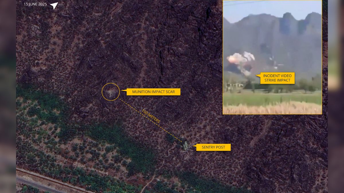
Damien Symon, a geo-intelligence researcher, posted satellite imagery from Google Earth dated June 2025 showing signs of impact in the Kirana Hills region. Symon pointed out two key observations: visible damage on the side of a hill near Kirana and repaired runway sections at the nearby Sargodha airbase. Both locations were captured in the aftermath of India’s strikes carried out in May during Operation Sindoor.
While Kirana Hills is a heavily fortified and closely monitored zone— alleged to contain nuclear weapon storage and underground research facilities— Symon clarified that the specific impact site appeared to be on “just one side of a hill with nothing of value in its immediate vicinity.” He suggested it may have been a calculated “warning strike,” rather than an attempt to inflict serious damage on high-value targets such as tunnel networks or nuclear storage bunkers.
Sargodha airbase, which lies in close proximity to Kirana, is one of Pakistan’s most significant military airfields. Its reported runway damage and subsequent repair, visible in the satellite images, support earlier claims that 11 of Pakistan’s 13 key airbases were hit during the Indian operation.
How did India respond to questions about the strike earlier?
Kirana Hills is considered one of Pakistan’s most sensitive military zones. It is believed to be a hub for nuclear weapons development, with underground tunnels, radar stations, and a concealed weapons storage network. The area’s proximity to Sargodha further reinforces its strategic importance, especially in the context of any potential India–Pakistan conflict.
Despite this, Indian officials have denied striking the location. In a press conference on Wednesday (May 12), Director General of Air Operations, Air Marshal AK Bharti, responded with sarcasm when asked about Kirana Hills: “Thank you for telling us that Kirana Hills houses some nuclear installations. We did not know about it.” He insisted that Kirana had not been struck, reiterating the same position he took during an earlier briefing.
However, satellite evidence now complicates that claim. The imagery, while not indicating damage to nuclear facilities themselves, confirms that nearby terrain was impacted and supports assessments that India’s strikes went deeper and were more strategically calibrated.